Earth Mysteries Articles
Introduction to Peru's Nazca Lines and Image Gallery
January 21, 2012 | Julian Laster
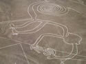
The lines are shallow designs made in the ground by removing the ubiquitous reddish pebbles and uncovering the whitish ground beneath. Hundreds are simple lines or geometric shapes; more than seventy are zoomorphic designs of animals such as birds, fish, llamas, jaguar, monkey, or human figures. Other designs include phytomorphic shapes such as trees and flowers. The largest figures are over 200 metres (660 ft) across. Scholars differ in interpreting the purpose of the designs, but in general they ascribe religious significance to them.
The geometric ones could indicate the flow of water or be connected to rituals to summon water. The spiders, birds, and plants could be fertility symbols. Other possible explanations include: irrigation schemes or giant astronomical calendars.
Due to the dry, windless, and stable climate of the plateau and its isolation, for the most part the lines have been preserved. Extremely rare changes in weather may temporarily alter the general designs.
Contrary to the popular belief that the lines and figures can only be seen with the aid of flight, they are visible from atop the surrounding foothills. They were first discovered by Peruvian archaeologist Toribio Mejia Xesspe, who spotted them when hiking through the foothills in 1927.
Excerpted from Wikipedia.org
Meccas Of The New Age Movement: Stonehenge
June 16, 2011 | Ginger Red Hawk
Who Built Stonehenge?
The question of who built Stonehenge is largely unanswered to date. The Danes, Romans, Saxons, Greeks, Atlanteans, Egyptians, Phoenicians, Celts, King Aurelius Ambrosious, Merlin and even Aliens have been credited with building this great megalith.
The best guess seems to be that the people of the late Neolithic period began the construction of Stonehenge and it was carried forward by the Bearer Folk. Their use of pottery drinking vessels and metal implements and their communal manner of living support this theory.
John Aubrey attributed the Druids with the construction of Stonehenge. According to him, these high priests of the Celts constructed it for sacrificial ceremonies. However, by the time of the Druids, Stonehenge had already been standing for 2000 years as recent discoveries have proven.
The legend of King Arthur also provides another theory. According to Geoffrey of Monmouth it was Merlin who brought the stones to the Salisbury Plain from Ireland. Sometime in the fifth century, there had been a massacre of 300 British noblemen by the treacherous Saxon leader, Hengest. The high king, Aurelius Ambrosius, wanted to create a fitting memorial to the slain men. Merlin suggested an expedition to Ireland for the purpose of transplanting the Giant's Ring stone circle to Britain and hence Stonehenge.
Building Stonehenge
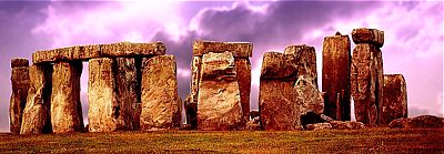
Stonehenge was built in three stages. The first stage happened around 50 centuries ago or 3100 BC when a circle of timbers surrounded by a ditch and bank was constructed. The ditch was probably dug by hand using animal bones and antlers. This is where the mystery begins. Excavators found not only the bones used for digging, they also found 56 holes that were dug to hold wooden posts. They were later named as Aubrey Holes after the 17th century antiquarian, John Aubrey, who found them in 1666.
Then in about 2100 BC Stonehenge was rebuilt. This time the 4 tonne bluestone megaliths from the Prescelli Mountains in Pembroke, South Wales (a distance of about 245 kms) were used. Considering that each stone weighs about 5 tons it must have been quite an amazing feat to transport the stones from Pembroke to Stonehenge. However, the second phase of Stonehenge was stopped before it was completed. No one is entirely sure for what reason.
Then in 2000 BC, work began again. This was the third and final stage and the Stonehenge that was built now turned out to be even bigger and better than the original one. The bluestones were dug up and rearranged and even bigger stones were brought in from Malborough Downs (about 32 kms from Stonehenge). These giant sandstones or Sarsen stones weighed in at about 25 tonnes each. The heaviest of them is said to weigh about 45 tonnes. The Sarsens were positioned in a circle and capped with morticed stone lintels. This is the Stonehenge as we see it today.
About 7 centuries later two mysterious rings of pits were dug around the stones. With the passage of time, the landscape around Stonehenge underwent considerable change and development. In the Neolithic period long barrows and huge earthworks such as the Cursus and Durrington Walls were created. In the Bronze Age hundreds of round barrows were built for the burial of chieftains or leaders, often with grave goods to support them on their journey into the next world. The Avenue, a ceremonial approach to the Stones aligned on the midsummer sunrise, was also built around this period.
Purpose For Building Stonehenge
Just as it is unclear who built Stonehenge and exactly when, the purpose for building it is also ambiguous. A monument of nearly imperishable quality, it was erected at a site of terrestrial energetic power recognized by the people of then. It was most definitely used as a device for astronomical observation used to predict the days in the annual cycle when the earth's energies were most influenced by the movements of celestial bodies. It was also a temple used to celebrate festivals of renewal during the energetically charged days. It was also built with materials chosen very carefully with specific intent. The diorite bluestones brought from 240 miles away show evidence of prior use in another religious structure; the micaceous, green-tinged "altar" stone of unknown origin, and the great sarsen stones all are positioned in a way as to resemble a pre-existing kind of sacred enclosure but, more important, to function as a sort of battery for gathering, storing, and ultimately expressing the earth energies of the site on the festival days. Lastly, perhaps we are given some indication of the power of the site by an old surviving record of an even more ancient folk memory.
The stones are great
And magic power they have
Men that are sick
Fare to that stone
And they wash that stone
And with that water bathe away their sickness
- "Brut" by Layamon, 1200 AD.
Meccas Of The New Age Movement: Machu Picchu
June 15, 2011 | Ginger Red Hawk
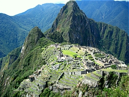
Machu Picchu (old peak) sits on a mountain site of breathtaking beauty in the middle of a tropical mountain forest. Giant walls, terraces and ramps which appear as though they have been cut naturally into the continuous rock escarpments make this city an architectural masterpiece. The Incas never used mortar. Most of the structures are built of granite blocks cut with bronze or stone tools, and smoothed with sand. The blocks fit together perfectly even though none of the blocks are the same size and some have as many as 30 corners. The joints are so tight that even a credit card can't be forced between the stones. Another unique thing about Machu Picchu's architecture is its integration into the landscape. Existing stone formations were used in the construction of structures, sculptures are carved into the rock, water flows through cisterns and stone channels, and temples hang on steep precipices.
The Architecture
The full extent of Machu Picchu's colossal conception can only be realized when you view the city from the nearby observatory of Intipunku. The city is an astounding achievement in urban planning, stonemasonry, architecture and civil engineering. The complex can be divided into three distinct sections: Religious, Agricultural and Urban.
Machu Picchu is comprised of about 200 stone buildings most of them residential. It is believed that about 1200 people lived in the city, most of them women, children and priests. The houses had steep thatched roofs and trapezoidal doors; windows were unusual. Some of the houses were two stories tall; the second story was probably reached by rope ladder. The houses, in groups of up to ten gathered around a communal courtyard, or aligned on narrow terraces, were connected by narrow alleys. At the center were large open squares; livestock enclosures and terraces for growing maize stretched around the edge of the city.
In the Southern part of the Urban section lies the 'jail'. Excavators found a series of niches carved on a rock with elements that included man size niches, stone rings that would have served to hold the prisoner's arms and underground dungeons. Next to the 'jail' are the 'intellectual's quarters' with tall walls, nooks and windows. These were accommodations for the Amautas or high ranked teachers. One of the quarters has several circular holes carved on the rock floor. This room is believed to have been used to prepare dyes and is called the 'mortar room'. The Royal sector has ample buildings typical of Inca royalty. Here lies the "Temple of the Sun", a circular tower with the best stonework of Machu Picchu and used for astronomical observations. Its base forms a cavern known as the Royal Tomb.
Towards the center of the citadel is the Religious section. It contains splendid architecture in masonry and stonework, the most impressive of which is the Intihuatana shrine. Intihuatana means "for tying the sun" or "hitching post of the sun". As the winter solstice approached, when the sun seemed to disappear more each day, a priest would hold a ceremony to tie the sun to the stone to prevent the sun from disappearing altogether. The Intihuatana was also used to make astronomical observations. The city is also home to the Great Central Temple and an attached smaller temple called the Sacristy. Finally, there is the "Temple of the Three Windows" so called because of the trapezoidal openings on the east wall. Recently, the "Temple of the Moon", located halfway down an underground chamber on the north side of the Huayna Picchu (young peak, an hour's climb from Machu Picchu) was discovered.
For agricultural purposes and to grow crops like potatoes and maize the Incas used advanced terracing and irrigation methods. They reduced erosion and increased the area for cultivation. The yield probably sufficed the people of the city but was not enough for export to Cuzco. This is yet another reason why Machu Picchu remained a hidden city until Bingham's discovery.
The fact that even five centuries in the grip of the Peruvian jungle has deprived the city only of its thatched roofs is proof enough of its endurance and strength and the depth of knowledge possessed by the Incas.
The Purpose
Exactly what the purpose of the city was is uncertain. It was most likely a royal retreat and religious estate. Built between 1460 and 1470 AD by the Incan ruler Pachacuti Inca Yupanqui, the city is situated high above the Urubamba River canyon cloud forest. Thus, a fair assumption is that the city did not have any administrative, commercial or military use.
From the way the city has been designed with large palaces and temples and residences for support staff, it is assumed that it was a royal retreat. It was also most definitely used for astronomical observations. Machu Picchu was thus a city of temples, palaces and observatories and was the home of the Inca ruling classes. From here, high priests made observations and calculations enabling them to chart the heavens - a knowledge which gave them both religious authority and temporal power.
How The City Was Lost
While the purpose for which Machu Picchu was built is fairly clear, there has been no concrete theory as to how the city was lost.
While the Spaniards invaded and ruined much of Peru, none of the Spaniards' chronicles make mention of Machu Picchu. Since the Spaniards took great pains to document everything in detail, it seems unlikely they ever discovered Machu Picchu. Wars between rival Inca tribes were common too. They often resulted in the annihilation of entire tribes. One theory believes this to be the fate of the citizens of Machu Picchu. Another possibility offered is that perhaps a novice priest defiled one of the sacred Virgins of the Sun. As per Inca customs anyone found guilty of sexually violating an 'ajilla' was not only put to death himself, but the inhabitants of the whole town including animals were slain. The entire place was damned so that no one could find it. One more theory suggests that the entire city was ravaged by an epidemic. The skeleton of a rich Inca woman suffering from Syphilis was found by Bingham. Perhaps the city was plagued and hence quarantined by authorities.
What brought about the depopulation of Machu Picchu is one of the deepest enigmas surrounding this sacred site. Whatever it was, the site remained untouched until Bingham discovered it in 1911 and then the world found Machu Picchu!
The Leyline Enigma
June 3, 2011 | Ceri Balston
The story of ley lines starts in 1922, when whilst sitting on a hill in Herefordshire, England, it suddenly struck Alfred Watkins, a businessman, trader and amateur archaeologist, that sites of historical or spiritual significance, churches, earth burial mounds and standing stones like Stonehenge for example, were aligned in perfect straight lines. After experiencing this revelation, "The whole thing came to me in a flash" he told his son, Alfred Watkins set about finding more leys and published his findings in his book "The Old Straight Track". In this book Watkins adopted the Saxon word 'ley' meaning 'a cleared glade' to describe his discovery, a word also closely linked to 'lea' meaning 'a track of open land'.
Watkins, perhaps because of his own profession, believed that these lines were evidence of prehistoric trade routes that had been cleared in a land previously covered in forest. Since the publication of "The Old Straight Track" however, many more theories have been suggested; some claim that they are evidence of the earth's invisible energy lines, others believe that they are navigational markers for UFOs and some have come to the conclusion that they are evidence of beliefs, that are found in cultures around the world, in the paths of the dead. Of course there is also a strong school of thought that dismisses the very existence of leys as mere statistical coincidences.
The Ley Rules
To determine the existence of a ley Waktins put together a set of rules that have formed the basis of all subsequent ley line discoveries. To be assigned the tag of ley line, according to these rules, three of more sites must be aligned in an exact line (measurements are made on maps); the greater the number of sites is stronger proof of the existence of a ley.
Watkins listed sites that he felt were not only prehistoric, including mounds and standing stones, but also included sites that he felt were linked to or based on prehistoric sites. To explain his inclusion of churches for example, he referred to a letter from Pope Gregory to one of his missionaries working in England which said that the "Temples of the English should not be destroyed but their idols should be smashed and their temples blessed with holy water with an altar setup in them". Circular moats, castles, churches, traditional wells, beacons, crossroads with names, bridges, fords and other sites were also included in his list for various other reasons.
Since the publication of his book 'The Old Straight Track' Ley Hunters (people who study maps and the landscape for evidence of leys) have found countless leys across Britain, France, Germany and even as far a field as Peru (Nasca lines).
Statistical Coincidence?
The existence of ley lines has been challenged ever since Watkins published his seminal work. One of the strongest criticisms is of Watkins' own methods of determining the existence of the lines. Ley Hunters, following his methods, find leys on maps drawing lines between any of the listed sites that can be used, if any three such sites fall along the same line it can be called a ley.
The most obvious problem with this method is that on a map with a given number of such sites the statistical probability is that an alignment will take place out of chance.
When determining his rules Watkins himself observed the occurrence of random leys. He marked 51 crosses at random on a sheet of paper and found no five-point, 1 four-point and 33 three-point leys. From this he concluded that studying a map with fifty sites that only a five-point ley was ironclad proof of deliberate alignment. Of course the sceptical statistician will still point out that this could still be chance and is therefore not proof.
Paul Devereux, who was editor of the Ley Hunter Journal for 20 years and is one of the leading authorities on the ley phenomenon, undertook a two year study of leys to prove or disprove their existence. He realised that;
"A lot of the alignments that Watkins had lined up were really just chance alignments of points on maps. This can be demonstrated quite conclusively; it's not just opinion. As I went on, I said, 'Bloody hell, there's nothing here' -- and that's a bit awkward when you're editing a magazine on the subject."
This revelation led Devereux to start a new research project to determine what explanations there could be for alignments that he referred to as being "actually physically there, archaeologically real, that are linear and unexplained". This research is still going on after 15 years and has taken Devereux all around the world.
Earth Energies
The idea that the earth is covered with lines of energy is not only found in Western Europe. In the aboriginal culture of Australia they are referred to as Song Lines, in Peru they are called the Nasca lines and in the Chinese practise of Feng Shui the earth's energy plays a significant role.
In Western culture the theory that ley lines were an indication of earth energies began with the research of archaeology Professors Alexander Thom and Gerald Hawkins. These two professors' compelling evidence largely changed previously held beliefs that Neolithic man had a very primitive understanding of their place in the universe and introduced the idea that they had advanced astrological, mathematical and engineering knowledge. It is now widely accepted that Stonehenge accurately plots the and rise and setting of the sun and moon as well as the change in the seasons. Their discoveries paved the way for speculations into what other skills Neolithic man might have possessed.
The publication of the 1936 novel "The Goat-Foot God" by occultist Dion Fortune, was the first to suggest that ley lines were evidence of the earth's energy fields. By the 1950's claims were made by Guy Underwood, a pioneer in modern dowsing techniques, that he could detect complex webs of energy under monuments, hill figures, old roads, paths and churches. In 1978 Tom Graves, another dowser, claimed that he was able to find a dowsable link between two such sites and resulted in the popular belief that leys were indeed evidence of energy lines that surrounded the earth and that the builders of monuments such as Stonehenge were aware of this. It was also suggested that monuments such as these act like giant acupuncture needles that have the ability to focus the earth's energy.
To prove or disprove this theory the Ley Hunters Society, the leading organisation on the study of leys, started The Dragon Project. Extensive surveys were undertaken of Britain's prehistoric sites and leys using dowsing, electromagnetic detection and other scientific instruments. After ten years of work they found no conclusive evidence to suggest that these sites, or indeed leys, possess any energy fields. They did however find that the sites they studied often had up to five times the amount of background radiation that occurs naturally, and that some of the researchers had visionary episodes that although only lasted for just a few seconds, were very, very vivid, with some people finding themselves in a whole other scene.
Some people have suggested that the high levels of background radiation triggered the hallucinatory episodes; others believe that these sites trigger some form of clairvoyance, allowing sight into the past, present or future. Whatever the reason the jury is still out on whether or not these sites have some kind of mysterious power.
Leys and UFOs
In the 1950's French UFO enthusiasts noticed that sightings of UFOs occurred in straight lines. In 1958, ex RAF pilot and UFO enthusiast Tony Wedd brought the concept of ley lines and flying saucer sightings together. This led to ley hunter Jimmy Goddard's rather fanciful idea; "could it be that the intelligences behind flying saucers built the ley markers for navigational purposes?"
Paths of the Dead
Recent research by Devereux and others has suggested that leys are evidence of perceived paths of the dead and other spirits, a belief that is held by many cultures around the world. In Ireland Fairy paths follow straight lines - it is believed that building houses on these paths will bring bad luck. In China spirits were believed to travel along straight lines and, unless decreed by the Emperor, straight lines were avoided at all costs. The Nasca lines in Peru connected ancient burial sites and are still maintained, through sweeping, today. In the harsh terrain of the Bolivian mountains, where spirits are believed to reside, paths follow straight paths, despite the challenging landscape. In the prehistory of Britain evidence of spirit paths are the cursuses, mounds of earth only observable from the air, that connect known burial sites, again in straight lines.
It is perhaps interesting at this point to also observe the English phrase -- "dead straight". Could this phrase have evolved from the belief that the spirits of the dead travel in dead straight lines?
A Leap of Faith I'm sure that when Alfred Watkins first made the observation of alignment whilst sitting on his hilltop he had no idea that he had started such a controversial topic. For him leys were merely evidence of prehistoric trading routes, not UFO navigation points, earth energy lines or paths of the dead. It is not surprising though, considering the strong spiritual pull that sites like Stonehenge possess, that the idea of leys being evidence of earth energy has become such a popular belief.
If you do believe that leys are more than mere statistical coincidences then a certain leap of faith is needed but then that is the case with anything that modern science cannot currently prove.
Ceri Balston is the editor of the lifestyle portal Harmonious Living. Visit www.harmoniousliving.co.za.